ShipPlotter
Live Maritime Traffic Viewer ~ Cook Inlet, Alaska
Ship locations are determined using the Automatic Identification System (AIS), which operates in the marine VHF band at 161.975 MHz (channel 87B) and 162.025 MHz (channel 88B)
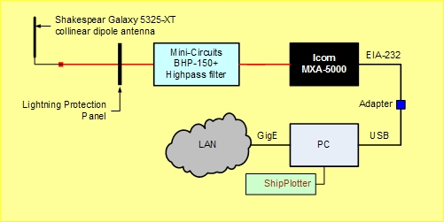
The equipment setup consists of an Icom MXA-5000 AIS Receiver, Shakespeare Galaxy 5325-XT, 8 ft collinear dipole antenna with 6.0 dBd gain, accessories and a PC running COAA ShipPlotter software as shown in the block diagram below.
Antenna location: 61-11-57.50N,
149-57-23.92W
Antenna elevation: 23.1 m AMSL (to antenna center)
Click here for system transmission budget diagram